Saturday, May 5, 2012

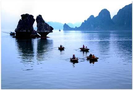
>> Sapa, the fanciful town in fog

“Well, Sapa brings in peace in a fine, rugged scenery and cultural diversity… a very sweet time for us!” remarked a young couple after their honeymoon in Sa Pa.


http://getvietnamvisa.org


Location

Sa Pa District is located in Lao Cai Province, north-west Vietnam, and 350 km north-west of Hanoi, close to the border with China. Sapa is famous both for its fine, rugged scenery and for its rich cultural diversity. French used to consider Sapa as Summer Capital of Northern Vietnam in the early decades of the 20th century. Its naturally gifted beauty keeps attracting more and more people to spend their vacation there since then. Particularly, the place is the foremost choice for honeymoon couples!

Geography & Weather


Geographically, Sapa is exactly a mountainous area of Northwest Vietnam. The whole Sapa District is dominated by the Hoang Lien Son mountain range which is at the Eastern extremity of the Himalayas, being famous with the Vietnam’s highest mountain of Fa si pan at a height of 3,142 m above sea level. The town of Sa Pa lies at an altitude of about 1,600 m, bringing in a cool and foggy site of Sa Pa.

Let’s join a fancy trip to this romantic town!

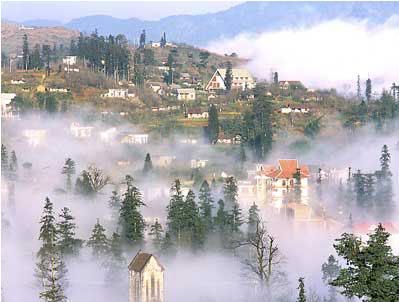
Taking a night train from Hanoi to Lao Cai, and then 45 minutes more from Lao Cai City by bus, Sapa appears in fanciful fog. Thanks to the height of 1,600 m above the sea level, the average temperature of the area is always 15-18°C, cool in summer, but a bit cold in winter.

Sapa takes its pride in its unique climate in Vietnam. It is highly seasonal, with a subtropical climate in the summer and a temperate climate during the winter. Mean annual temperature for Sa Pa town is 15.4°C, with a maximum of 29.4°C and a minimum of 1°C. The warmest months are July and August, and the coldest months are December and January. Snow falls in some years on the highest peaks. In the morning and afternoon, it is as cool as in spring and autumn. Yet, at noon, it is as sunny and cloudless as in summer. In the evening, it drastically changes into coldness just as in winter. This is actually a unique advantage, making Sapa different from anywhere else in the nation. However, travelers should be noticed that there might be sudden thunderstorm and heavy rains at noon in summer. Yet, subsequently, a rainbow appears turning Sapa into a beautifully magic land with seven colors! So, remember to bring your best camera so as not to miss this magnificent view!

April and May are the best time for tourists to watch the most scenic beauties of Sapa, or else it might be cold and foggy before that and rainy after that. During these two peak months, the town is blossoming with pink and white flowers, and green pastures in valleys. The clouds that settle in the valley in early morning would quickly disappear.

Beauty Spots and Resorts

The scenery of the Sapa region in large part reflects the relationship between the ethnic minority people and nature. This is seen especially in the paddy fields carpeting the rolling lower slopes of the Hoang Lien Mountains. The impressive physical landscape, which underlies this, has resulted from the work of the elements over thousands of years, wearing away the underlying rock.

Most tourists agree that it would be regretful if the leisure and relaxation time in cool and fresh weather is not accompanied by visiting trips to Sapa’s prideful natural beauty spots, such as Ham Rong Mountain, Silver Waterfall, Rattan Bridge, Bamboo Forest and Ta Phin Cave. The town is also the starting point for many mountain climbers and scientists who would like to discover the Fansipan Mount, the highest mountain in Vietnam with 3,143 m height. Can you imagine that Hoang Lien Mountain Range is called “the Alps of the North Sea area” since Fansipan Mount also marks its greatest height among others in the Indochina Peninsula as well. The pyramid-shaped mountain is covered with clouds all the year round. On top of the mountain is filled with frequent below zero temperature, especially at high altitudes.

On approaching the town, the very first thing tourists may find is the detached wooden mansions and villas perched on top or side of the hills, behind thick pine forests, hided by fog in the morning. Old and new villas with red roofs now appear and then disappear in the green rows of pomu trees, bringing in the beauty of European towns.

Flowers

http://getvietnamvisa.org
Sapa-the land of love

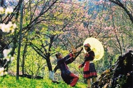
Sapa is home to various families of flowers of captivating colours, unique in the vast country. When Tet, the Lunar New Year Festival, comes, the whole township of Sapa is filled with the pink colour of peach blossom brought from the vast forests of peach just outside the town. Sapa is regarded as the kingdom of orchids. Here, orchid lovers are even amazed by the choice, when trekking in the forest filled with several hundred kinds of orchids of brilliant colours and fantastic shapes, such as Orchid Princess, Orchid of My Fair Lady's Shoe. Some orchids are named after lovely singing birds such as the canary, salangane's nest, and more.

Specialties

Foreign tourists are actually fond of scarce and precious specialties of Sapa, such as forest’s product, handicrafts, delicacies (smoked meat, “thang co”, “cai meo”, san lung wine, corn wine, etc.), typical of ethnic minority people.

Most travellers do like to bring some of the local fresh vegetables back home for presents. Thanks to the fresh and cool air, Sapa is the ideal land for fresh temperate vegetables such as cabbage, chayote, precious medical herbs, fruit trees (plum, pear), and so on.

Cultural diversity


Sapa is famous for its special cultural diversity in a combination of ethnic minority groups’ culture. Visitors to Sapa will have opportunities to discover the unique customs of the local residents. Local markets are the town’s typically cultural element, which are always crowded and joyful, attracting hundreds of visitors. This is the common place for minority groups to gather and exchange goods.

Market sessions are also a chance for local people to promenade. No foreign visitor could help joining such a market session, a typical cultural element of Sapa. What is more, tourists coming to Sapa at weekends have the great chance to learn about local ethnic people's courtship and martial life, through the Sapa love market and wife kidnapping ceremony of the H’Mong group. The ceremony will begin on April 29th. This is part of a five-day festival, titled Festival on the Cloud, to mark the beginning of the Sapa 2006 tourism year, in the northern mountain township of Sapa, in Lao Cai Province.

If ever asked to drop a quick comment, even the toughest person must admit the romance and peace of a magnificently cool and beautiful Sapa! I hope you should spend a short summer here, and you will soon share the idea!

Close to Hoi An town, Cu Lao Cham really cherishes high potential for tourism development.

Friday, May 4, 2012

>> “South second nicest grotto” : Tam Coc-Bich Dong

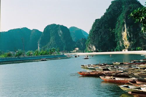
Tam Coc – Bich Dong is also called “A terrestrial Ha Long Bay”, or the “Vietnam’s second nicest grotto” (to Huong Tich) for its poetic and inspirational natural scenery.


http://getvietnamvisa.org
Briefings

Located in the Ngu Nhac Son Mountains, Hoa Lu District, Ninh Binh Province, it is a grandiose complex of Bich Dong pagoda and Tam Coc grotto which is one among the 21 crucial tourism destinations of Vietnam.

The zone is featured with a tropical climate, with 2 seasons. The cold and rainy season lasts from May to October, and the dry and hot season from Novermber to April. Its annual average temperature is 23.5oC. As situated at the base side of the Red River Delta Triangle, it is a half-mountain half-plain area, with a coastline of 18 kilometers.

King Le Canh Hung ever said: “This is Vietnam’s second nicest grotto, after the Huong Tich Grotto in Ha Tay province”. Its pristine natural beauty together with a simple but nice countryside landscape, and a sacred spiritual life have converged into a fascinating and attractive Tam Coc-Bich Dong to numerous tourists.
These days, more and more people in the world have been coming here in various types of tours: ecological tours, culture, history, and festival tours. No one could deny that Tam Coc-Bich Dong has become a legend of rivers and mountains, a green, pure, and safe destination for every traveler.

Historical name

Bich Dong is a beautiful pagoda on the nearby Ngu Nhac Mountain dated to 1428 under the Le Dynasty, comprising three structures: Ha, Trung, and Thuong Pagodas, in ascending order. In 1773, Mr. Nguyen Nghiem (the father of the great writer Nguyen Du) visited this cave. He was much impressed by the whole magnificent scenery of mountains, waterways, fields, and sky covered in green mist. Thus he gave it a very beautiful and romantic name, Bich Dong, which literally means “Green Pearl Grotto”. This picturesque landscape is added by Tam Coc portion. It derives its name from its consisting of 3 caves (Hang Ca, Hang Hai, and Hang Ba); “Tam” means 3, “Coc” means cave. Tam Coc or “Three Caves” portion is of great enchanting charm and mystery, inviting tourists to come and explore!

Join a round trip!

Tam Coc Wharf – starting point of journeys

To begin the journey, tourists have to queue at Tam Coc Wharf to take a boat to travel along rivers. The pier is crowded with tourists from morning till afternoon. People coming here share the same pleasant feeling about such a nice picture with the classical communal house, ancient banian tree, mossgrown well, marble rock, and friendly locals.

Tam Coc – a mysterious grotto

Visiting Tam Coc Grotto, tourists may feel like they had just disappeared from the real world to get lost in such a hidden fairy site, which is located approximately 2km from the pagoda. Tam Coc is 3 kilometers from Van Lam Wharf. Now just take a boat from Van Lam Wharf to reach the Tam Coc Grotto, which consists of the Hang Ca, Hang Hai and Hang Ba caves. This might take you three hours on your small boat along the Ngo Dong river, beginning at the village of Van Lam and proceeding through a scenic landscape dominated by rice fields and karst towers. The largest of the grotto is 125m long with its ceiling about 2m high above the water. This grotto is adorned with beautiful stalactites and stalagmites of different shapes and colours that sparkle like gemstones. Now when drifting along the gentle Ngo Dong River under the Grotto, you can feel the deeply pure atmosphere with special smell of fresh rivers water and cool air from karst mountains when reaching each of the 3 caves in turns.

Among the three caves, Hang Ca is considered the most picturesque one since it is the longest and contains most fascinating natural arts deep inside. It is around 127m long, with a cave mouth of 20m wide. When leaving Hang Ca, just turn back to see it once again, you will feel that it were like a very old white-haired man sitting down for fishing. A Vietnamese legendary tells that this was a Heaven Land where that fishing man – a considered fairy one – lived, and flying above within the Heaven was a flock of fairies in graceful white dresses! You may be so much seduced by the beautiful fairy landscape that you do not even think of coming back at that time!

Hang Hai is nearly 1 kilometers far from Hang Ca. This is the second stop-over on your waterway journey, where can be found a series of colorful sparkling stalactites falling from the cave ceiling. This cave is about 60m long. The last but not least cave is Hang Ba, just nearby, is about 50m long, with lower ceiling than the above two, looking like a plutonic cupola.

Now getting out the whole grotto, looking out the vast landscape, you can see that a mighty mountainous and waterways are covering the limitless land. If moving further 4 kilometers, there comes “Fairy Stream”, a pure mirror-like stream where you can even see through to the stream-bed to contemplate flocks of fish swimming and looming in the moss layers. It is said in a fairy tale that fairies used to land on here to swim, thus it was named “Fairy Stream”.


http://getvietnamvisa.org
Bich Dong


Bich Dong Grotto

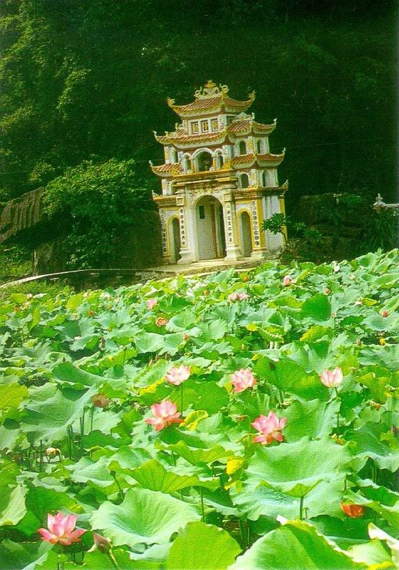
Now turning in the opposite position, you will soon reach Bich Dong pagoda, which is situated at the grandiose Ngu Nhac Mountain. The Pagoda is divided into three levels: Ha Pagoda (lower pagoda), Trung Pagoda (middle pagoda), and Thuong Pagoda (upper pagoda). On the mountain peak stands the statue of a scholar Mandarin looking at the horizon with the hope of viewing the spectacular landscapes of Hoa Lu. Visiting Bich Dong grotto, tourists have a great chance to turn back to the Post Le Dynasty’s legends.
From the upper pagoda, one has the most magnificent view of Bich Dong, which is romantically charming in terms of architecture and history. The location for this pagoda was chosen in 1428 after two monks were charmed by the view of the river and the mountains. Later, King Le Canh Hung wrote a poem in honour of the beautiful pagoda and landscape.

Bich Dong means “Green Grotto” or “Pearl Grotto”, which reveals its magnificient natural beauties. Colors, shapes, and sounds of the shining stalactites converges in such a captivating miracle that no one could refuse to touch, knock and contemplate them in deed. Honorably, amongst the most fascinating caves in Vietnam, “Fairy Grotto”, part of Bich Dong, is regarded as an “Elysium on Earth”.

"Surrounding mountains full of water during 4 seasons,
Rattan boat lightly drifting,
Covered with mist and clouds, is Pagoda landscape”
are beautiful lines of verse offered to Bich Dong pagoda grotto, a rare natural work of Art.

”Sun Valley” – attractive ecological tourism

Here comes the final destination in your meaningful waterway journey – “Sun Valley” (Thung Nắng), an ideal ecological tourism spot for lovers of nature. Inside the valley, there is an ancient limestone temple with rock-style architecture shown in delicate carvings. Visiting this valley, you can relax in your small boat, with sun-bathing and sun playing in a quiet and pure atmosphere.

“Marvellous landscape, considerate service!”, said Ms Mery Luit, a German tourist, “if possible, I will soon come back to Tam Coc-Bich Dong”.

Tourist activities

Taking a boat journey to: Tam Coc (from Van Lam Wharf on Ngo Dong River), Crossing Thuy Dong (through Ngu Nhac Sown Mountain range), Thach Bich-Thung Nang, Thung Nham-Vuon Chim, Linh Coc-Hai Nham, etc.
Walking and mountain climbing: Bich Dong Mount and Pagoda, Tien Grotto, Thien Huong Grotto, Co Vien Lau ancient houses

Close to Hoi An town, Cu Lao Cham really cherishes high potential for tourism development.
Wednesday, May 2, 2012

>> Ghenh Da Dia

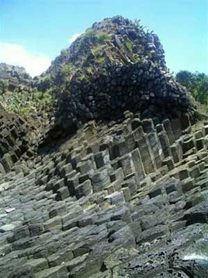
With natural stones, strangely structured rocks, columns or obliques of frozen mineral flows, Ghenh Da Dia (Rapids of Stone Plates) is considered as a masterpiece of stone gifted by the nature.


http://getvietnamvisa.org


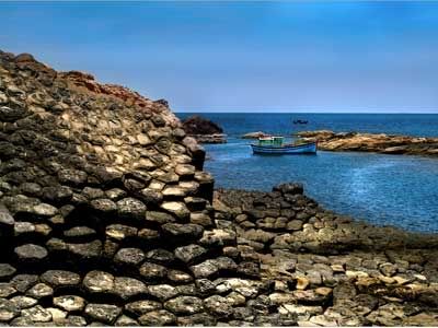
Located in An Ninh Dong Commune , Tuy An District, Phu Yen Province, Ghenh Da Dia is strangely structured rocks include large upright stones equally arranged in a star pattern. Being a riddle of nature, like a giant jigsaw, the rapids is irritatingly made of the same shaped pieces, and forms a solidified structure that has proved more than just a curiosity for thousands.

A strange geological phenomenon

Millions of years ago, during volcano eruption, mineral flows melting will be frozen when they encounter water and then the solid breaks into columns or obliques. That created the beautiful landscape of Ghenh Da Dia for the present time. Time over time, the landscape is rearranged as an artistic work by the hand of nature. Ghenh Da Dia is about 1km2 large, half in the sea and half above sea level.

Looking down on it, visitors often liken it to a gigantic beehive, others as a pile of stone plates. For despite a lengthy series of historical, archeological and scientific probes of the cliff’s square kilometer, its formation remains a mystery.

The stones in Ghenh Da Dia are bazan stones of dark black and light yellow. There exists large stones of tons and small stones with different shapes: round, pentagon, polygon and so on. The stones take the right column or a settlement close to each other like disks arranged on couples together. Even counting the stone columns has failed to yield an exact figure as exhausted researchers usually call a halt at around 35,000. The stones are 60-80cm in visible height and 20-30cm across and cluster round a small fresh water pond that is fed by underground rivers and never dries up.

And a wild beauty...

In Ghenh Da Dia, there only remains the unique scenery of the sea and stones, so everything is still primary, environment is so pure, air is fresh and comfortable.


http://getvietnamvisa.org


Besides Ghenh Da Dia is Bang beach, with rocks “lie” quiet under the shadow of trees. This is quite ideal for relaxation, camping and extra activities. Ghenh Da Dia and the beach are closed with a famous tourist attraction which is "Hòn đá lực lượng" - a deep and wide grotto that saves the legendary people in a war period. In the war, our main force sheltered in the cave at night, waiting to the day to go on a sortie and dealt enemy thunderstruck blows.

Visiting Ghenh Da Dia, you have a chance to view many species of marine creatures, especially “Mứt” seaweed - a type of kelp which is salty and sticks to the stones, looking like a network.

Have been listed as a National Heritage Site by the Ministry of Culture and Information, Ghenh Da Dia is a potential tourist attraction to both domestic and foreign visitors. And a visit to the rapids, you will be certainly worth it...
Close to Hoi An town, Cu Lao Cham really cherishes high potential for tourism development.
>> Son Dong, the world's largest cave

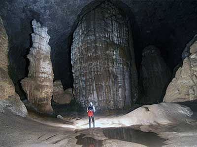
Son Dong, a cave belongs to the Phong Nha-Ke Bang grotto system in central Quang Binh Province, has been discovered to be the biggest in the world.


http://getvietnamvisa.org


Son Doong cave, discovered by a local 18 years ago, is more than 200 meters wide, 150 meters high, and at least 6.5 kilometers long, though the explorers said they were unable to explore it fully. Bristish explorers have recently discovered that So Dong is much larger than the world’s biggest known cave.

The biggest section of Son Dong is five kilometers in length, 200 meters high and 150 meters wide, said Howard Limbirt of the British Cave Research Association team searching the area April 10-14, 2009.

Son Dong is much larger than Deer Cave in Malaysia, currently considered the world’s largest, an explorer said (Deer is 90 meters wide, 100 meters high and 2 kilometers long). The Son Doong cave has replaced to take pole position as the world’s largest cave.

The Son Dong is situated below another cave in Phong Nha-Ke Bang, though its entry passage is very difficult to traverse. The exploration team said they had set foot on just 6.5 kilometers along the cave, as there is a large amount of fast flowing water inside Son Dong. It takes explorers six hours of walking through a 10 kilometer long forest path from Truong Son Highway to reach the mouth of Son Dong cave. The explorer added that the Quang Binh cave has beautiful stalactites and stalagmites that are not seen anywhere else.

Phong Nha-Ke Bang grotto system belongs to the Phong Nha-Ke Bang National Park. It is a limestone region of 2,000 square kilometers in Vietnam and borders another limestone area in Hin Nammo in Laos. When describing the newly-discovered cave, the team’s spokesman, Haward Limbirt, said that it was a thing of overwhelming beauty and grandeur.

He added that each grotto has its own beauty, but he is impressed by Ca Xai. This cave is near the Vietnam-Laos border. It is very deep and has a big lake inside. Explorers measured the depth of this lake, but they had only 200m of rope and the end didn’t reach the lake bed.

The British team suggested to the local authorities not to develop Son Doong Cave as a tourism site immediately to preserve its natural beauty.

Tuesday, May 1, 2012

>> Ha Long Bay – a magnificent magical destination

Ha Long Bay is said to be a magic land of natural sea bay beauty, attracting more and more tourists ever since UNESCO’s recognition of its nature !


http://getvietnamvisa.org


Location & Climate

Halong Bay is located in the Northeast of Vietnam, belonging to Ha Long city, Quang Ninh Province, in the Gulf of Tonkin. On the world map, it has borders to China in the North and adjacent to the East Sea in the East .

The Bay has a medium size of 1,553 square kilometers. It is accomodation of many fishing communities, including the 4 communes of Cua Van, Cong Tau, Vong Vieng and Ba Hang with a population of more than 1,600 people. The residents live on floating houses and boats, making their own lives by fishing and aquaculture.

The bay is a sea islands in tropical wet with 2 seasons: hot and moist summer, dry and cold winter. Average temperature is from 15°C- 25°C. Annual rainfall is between 2,000mm and 2,200mm. Halong Bay has the typical diurnal tide system (tide amplitude ranges from 3.5-4m). The salinity is from 31 to 34.5MT in dry season and lower in rainy season.

Historical name

Literally, “Ha Long” means "Bay of Descending Dragons." Before the 19th century, this name was not recorded in any document or archive. In this term, there is a mysteriously legendary tale as follows
“Long ago, in the first founding days, the Viet people were attacked by foreign aggressors. The Jade Emperor sent the Mother Dragon and her band of Child Dragons to help the Viet people fight the invaders. While the enemy vessels were launching massive attacks against the mainland, the dragons descended in flocks from the sky.

They spat out innumerable pearls which changed into jade stone islands the moment they touched the water. These islands linked together to form firm citadels that checked the enemy’s advance and smashed their vessels to pieces. After the invaders were driven out, Mother Dragon and her Child Dragons did not return to Heaven but stayed on earth, right at the place where the battle occurred. The spot where the Mother Dragon landed was Ha Long, and where the Child Dragons came down was Bai Tu Long. The place where their tails violently wagged was called Long Vi, the today’s Tra Co Peninsula with its soft sandy beach stretching a series of kilometers.”

Gifted Beauty & top sightseeings

In 1962, the Ministry of Culture and Information classified Halong Bay as a National Landscape Site, covering an area of 1,553 km2 with 1,969 islands. Halong Bay has been recognized twice by UNESCO as a World Heritage Area for its universal values of landscape, geology and geomorphology, respectively in 1994 and 2000, an area of 434 sq. km. including 775 islands.

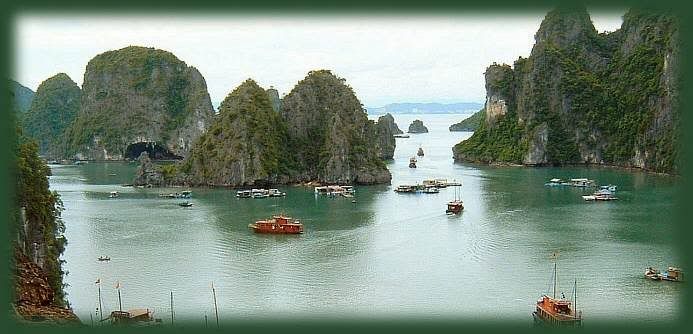
The dense cluster of 1,969 limestone monolithic islands within the bay is topped with thick jungle vegetation, which rise spectacularly from the ocean. Most of the islands were formed over 500 million years ago, and massed in the Southeast and Southwest. Those in the Southeast have an average height of 50-200m, covering lots of flora. Several of the islands are hollow, with enormous caves. Hang Đầu Gỗ (Wooden stakes Cave) is the largest grotto in the Ha Long area. French tourists visited in the late 19th century, and named the cave Grotte des Merveilles.

Its three large chambers contain large numerous stalactites and stalagmites (as well as 19th century French graffiti). There are two bigger islands, Tuan Chau and Cat Ba, that have permanent inhabitants. Both of them have tourist facilities, including hotels and beaches. There are a number of wonderful beaches on the smaller islands. The others are Bai Chay, Ti Top, Minh Chau, Quan Lan and so forth.

Viewed from above, Ha Long Bay looks like an extremely vivid huge drawing, and sailing beneath the bay is like leisuring in between a huge valey on water. Ha Long bay is exactly a wonderfully skillful masterpiece of Nature that turns thousands of dumb soulless stone islands into fantastic sculptural and artistic works of various graceful shapes, both familiar and strange to human beings. Thousands of islands emerging in the fanciful waves look strong and magnificent but also mild and vivid. Amidst these islands tourists may feel as if they were astrayed in a petrified legendary world.

The names given to the islands were based on their shapes and forms, such as, Human head Island, Sail island, Fighting cocks islands… Inside the stone islands are various breath-taking caves like Thien Cung, Dau Go, Sung Sot, and others. These are really magnificent palace of many huge stalactites hanging poised in mid air and stalagmites growing majestically upwards. Ha Long’s sea is always the same, blue, smooth and still.


http://getvietnamvisa.org


What is more, the bay has its own seasoned beauty. In Spring, buds of trees burst on limestone islands. In Summer, it is cool and clean with many sparkling sun rays reflecting from the sea’s surface. In Autumn, especially at night, moonlight illuminates the mountains, making them like gold, inlaid into the earth. In Winter, with pervasive frost, Ha Long is glamorous as “a floating flower basket on smooth wave” (by writer Nguyen Tuan). All of them, stone, water and sky, make the Aesthetic value of Ha Long Bay.

The Bay’s Geological value is evaluated in two ways: by the history of its formation and its karst geomorphology. It is also home to the ancient Viet people beginning from 7,000 to 18,000 years ago, Ha Long’s Cultural − Historical value. Besides, Bio-diversity is an important natural resource, to be well-conserved so as to maintain the ecological balance of the whole region.

Ha Long Bay is undoubtedly not only a national but also a world nature, a magnificient work of Natural Creator. People who are admirers of natural beauty should stand up, pack their luggages, and right away pick up a flight to Ha Long, or else they will soon feel regretful !

>> Cu Lao Cham, the beautiful offshore island

Cu Lao Cham is known as a beautiful island with various wild animals and legendary landscapes.


http://getvietnamvisa.org


The large island consists of eight islets, 20 kilometres off the coast from Hoi An Ancient Town in Quang Nam Province. Cu Lao Cham Island has wonderful sand beaches, forested hills and the sea. With primitive landscape, the island is ideal for camping, swimming and scuba diving to enjoy the corals and beautiful marine life.

At the summer, if you reach for the island by normal boat, it takes 2 and half hour, but only 30 minutes by speed boat. There are 10 guesthouses for tourists who don’t want to spend the night in a tent on the beach. Transport from the mainland to the islet is quite comfortable.

History

Cham islands are supposed to be the first place where Cham people landed, coming to Quang Nam Province from Indonesia (small monuments, dikes and basin to grow up rice on terraces are hidden in the forest, 17th century pagodas and small temples in the two villages). Therefore, being well-known since earlier Cham domination (from 4th to 14th century), the island became one of the main port of Champa Kingdom. Situated some eight miles offshore Hoi An, it was also part of Hoi An historical international trading. From 15th century till the beginning of 20th century, the old city was a meeting point for international vessels and junks.

According to archaeologists, Cu Lao Cham first settled there 3,000 years ago and established business contacts with external countries some 1,000 years ago. Up to now, Cu Lao Cham has preserved many architectural constructions which date back to the 18th and 20th century. They include the shrine dedicated to Than Yen Sao, built in 1843 at Bai Huong and Hai Tang Pagoda, built in 1753 on the western hillside of Hon Lao. Still, Cu Lao Cham has more to offer. After a three-hour canoe trip, one may hop over to the famed Well of the Cham people.

Topography

The island comprises an archipelago of one large island and seven smaller islands. The largest island - Hon Lao, covering 1,317 ha, is circle shape at the high of 500m. There are nice beaches at Bim and Ong beach. The topography of Cu Lao Cham Island is dominated by two peaks: a 517m peak in the centre of the island and a 326m peak at the western end. Natural forest here covers 532 ha of the nature reserve, equivalent to 35% of the total area, while plantation forest covers a further 30 ha.

Biodiversity values

The island is a place where shelter for value swallow birds. The natural vegetation of the islands is lowland evergreen forest, that is natural with a lot of woods and rare animals.

Scientists report the occurrence of macaques Macaca sp., monitor lizards Varanus sp. and pythons Python sp. To date, 265 vascular plant species have been reported from the nature reserve. Furthermore, a species of swiftlet Collocalia sp. is reported to nest on Hon Kho within the nature reserve.

Cu Lao Cham is also home to salanganes, birds whose nests have long been considered a delicacy by aristocrats and the wealthy. The nests may cost as much as US $4,000 per kilogram. In a beautiful day, tourists are able to see cliffs where salanganes build their nests and talk with salangane-nest takers.

Around the island has a lots of color corals under the water. Situated in a salty-water area, this square-bottom well, amazingly, provides clear fresh water all year round. Enjoyable extras include white-sand, pristine beaches and captivating attractions evocatively named Bai Ong, Bai Bim, Bai Chong, Bai Bac, Suoi Tinh, Cau Mo, Suoi Ong and so on, where tourists can relax, go hunting, fishing even fishing octopuses.

Visiting Cu Lao Cham, you also have chances to view the sea swallows' nests clinging to the towering cliff. Cu Lao Cham wins kudos for its seafood and delicacies (octopuses, lobsters, fish's fin, abalone, kaki, hind, cholonia's eggs, bird's nests) and fascinating souvenirs (pearls, conches, tortoise-shells).

Moreover, you can take a tour to Lang beach for seeing some interest places as such Au Thuyen-a shelter for boats at bad weather, a 100-year Tay Tang Pagoda remarking the Puddhism that came here for long time ago, Ong temple - a place worshipping a big fish burried here.

Close to Hoi An town, Cu Lao Cham really cherishes high potential for tourism development.